Skip to main content Skip to footer

History and Heritage

The Township of Hamilton, located in central Northumberland County, has deep agricultural roots that go back to the late 1700s, when United Empire Loyalists and other settlers began farming the land. Named in 1791 after Henry Hamilton, then Lieutenant Governor of Quebec, the Township quickly became known for its grain crops, fruit orchards, and livestock. Many of the stone fences, barns, and homesteads built by early families still stand today, lasting reminders of a strong rural tradition.

Long before European settlement, this land was home to the Mississauga Anishinaabeg, whose enduring connection to the region is recognized through the 1923 Williams Treaties. Today, the Township’s identity is shaped by both its Indigenous and settler heritage. With Lake Ontario to the south, Rice Lake to the north, and the Town of Cobourg nearby, Hamilton remains a close-knit farming community surrounded by natural beauty and history.

Preserving Local Stories

The Northumberland County Archives and Museum (NCAM) safeguards the region’s historical records and artefacts, including those from the Township of Hamilton. NCAM is currently preparing to reopen in fall 2025 in a new, purpose-built space that will include expanded public access and community programming.
To explore local history and archival collections, and view the new facility visit Northumberland County Archives and Museum

Heritage Designated Properties

The Heritage Advisory Committee works under the Ontario Heritage Act to provide and prepare the criteria for the evaluation of properties of architectural/historical value (or cultural heritage); to increase public awareness of heritage conservation; prepare a yearly report of activities and to keep the register of historic properties up to date. 

Heritage Designated Properties are recognized under the Ontario Heritage Act for their cultural, historical, or architectural significance. These properties are listed on the municipal Heritage Register, which helps ensure their protection and conservation for future generations.

On September 17, 2024 Council approved the Updated Municipal Heritage Register.

Township of Hamilton Historical Plaques

The Township of Hamilton’s Heritage Advisory Committee has gathered fascinating information and photos highlighting our six historical plaques, each telling a unique story from our community’s past.

The Township is rich in heritage and surrounded by remarkable historical landmarks. Whether you're a history enthusiast or simply curious about the area, the Township of Hamilton invites you to discover the stories and landmarks that helped shape our community.

Location: Gore's Landing Pioneer Park

dignitaries posing for the unveiling of a plaque in 1968

Named after Thomas S. Gore, an Irishman who settled in this vicinity in 1845, the Village of Gore's Landing prospered for a time as the terminal point of a plank road construction from Cobourg to Rice Lake, 1847-48. Among the well-known residents of Gore's Landing were Archibald Lampman (1860-1899), noted poet; Derwyn T. Owens (1876-1947), Anglican Primate of All Canada from 1934-1947; J. D. Kelly (1862-1958), historical artist; and Gerald S. Hayward (1845-1926), a painter of miniatures who won acclaim in the U.S. and Britain. Hayward contributed to the building of the present St. George's Anglican Church, constructed of stone in 1908 to replace the wooden church erected 1846-48, and is buried in the adjacent cemetery.

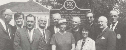
Erected 1968 by the Province of Ontario, Department of Public Records and Archives, and the Archeological and Historic Sites Board of Ontario.

Location: Harwood Road, (Lot 6, Concession 8)

In 1854, fourteen German immigrants who had been working on the construction of the Cobourg and Peterborough Railway died of cholera while on this property. They were buried in unmarked graves beside the railway berm. In 1882, J.R. Barber, a former superintendent of the railway, erected a wooden cross to mark the burial site. The inscription on the cross reads:

In memoriam, fourteen German laborers who died of Cholera, 1854, and buried in Potter's Field.

In 1987 the memorial was restored by the Cobourg and District Historical Society, the Township of Hamilton, and the Ministry of Citizenship and Culture.

Location: McClelland Road (Lot 32, Concession 4)

Boltus Harris, United Empire Loyalist from New York, was granted this property in 1797. Known as the Township's "first settler," Boltus, his family, and other settlers, are buried here on the hill just south of the creek. In 1832, the lot became Melsetter Farm, the first home in Canada of Dunbar and Susanna Moodie. Moodie's book, Roughing It In The Bush, relates the story of the Harris family she found here and her adventures with them.

The Bicentennial of the Province of Ontario was celebrated in 1984.

Location: Harwood Hall, 5453 Front Street, Harwood

This area was purchased in 1828 by Robert Harwood, a merchant from Montreal, but significant development did not occur until the arrival of the Cobourg and Peterborough Railway in 1854. The village of Harwood was surveyed in 1855, and the railway, used to transport passengers, lumber, and goods to Peterborough, and later ore to the Marmora iron foundry, spurred commercial growth in the area.

A key feature of the railway was the nearby crib bridge across Rice Lake; however, due to poor engineering and construction, the bridge was closed in 1862. The line also faced strong competition from the Port Hope–Peterborough Railway. With the decline of the local lumber industry, rail service on the Cobourg and Harwood line ceased in 1895.

Erected in 1971 by the Archaeological and Historic Sites Board and the Department of Public Records and Archives of Ontario.

Location: Cavan Road, (Lot 28, Concession 7)

Born on this property, Mina Benson was an early 20th-century Canadian explorer and writer. Between June 27 and August 27, 1905, she retraced and completed the ill-fated 1903 Labrador expedition of her late husband, Leonidas Hubbard, covering 576 miles from the Northwest River to Ungava Bay. Her field surveys, among the first to document the Naskaupi and George River systems, were accepted by the American Geographical Society. In 1908, she published her account as A Woman’s Way Through Unknown Labrador. Benson later remarried, raised three children, and settled in England, where she passed away.

The commemorative plaque was erected in 1996, the Bicentennial Year of the Township of Hamilton, with support from the Ontario Heritage Foundation and the Cobourg and District Historical Society.

Location: Lander Road (Lot 19, Concession 8)

In May 1847, Catharine Parr Traill (1802-1899) one of Canada's distinguished early writers, moved with her husband, Thomas, and family from Wolf Tower to this farm which they named Mount Ararat, "the highest elevation on the Rice Lake Plains". This property is the locale of Mrs. Traill's famous book for children, Canadian Crusoes (later called Lost In the Backwoods). In the spring of 1849, the Traill family moved a few miles east to Oaklands on Traill Road, their third home in the eleven years.
This plaque was erected in 1985 by the Township of Hamilton and the Ontario Ministry of Citizenship and Culture.

Land Acknowledgement

The Township of Hamilton is situated within the traditional territory of the Mississauga Anishinaabeg and Chippewa Nations, collectively known as the Williams Treaties First Nations. Our work on these lands respectfully acknowledges their resilience and their longstanding contributions to the area now known as the Township of Hamilton.

Stay Connected!

Stay up to date on activities, events, programs and operations happening in the Township by subscribing to our news and updates.

This website uses cookies to enhance usability and provide you with a more personal experience. By using this website, you agree to our use of cookies as explained in our Privacy Policy.